Ghost train
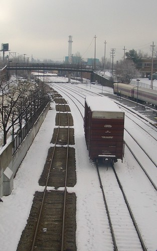
I commute by train to work every morning. Normally in Lowell the siderails are filled with boxcars. This morning they had left, but not without leaving evidence.
Ghost train
I commute by train to work every morning. Normally in Lowell the siderails are filled with boxcars. This morning they had left, but not without leaving evidence.
Trash piano
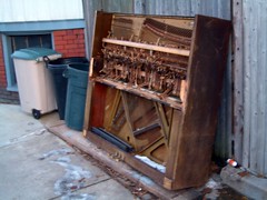
Desensitized to all the brightdangle and claptrap for purchase in the stores these days, I am mesmorized by the things people throw out and can throw out; this piano carcass being no exception.
Walking in Circles
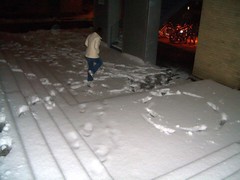
Jess and I were up at MIT to see a friend and coworker in a MIT Community Players production of Autobahn, a series of 7 one-act plays taking place in the front seat of an automobile, by Neil Labute. She was great, the plays themselves were ok and a little redundant by the end.
Leaving the building we had to tread through some relatively thick snow. We tried to follow the footprints of others, though as the photo shows, some of them were a little less than efficient at getting anywhere.
A hole in the ice

I snapped this photo just this morning. Lowell, America’s Venice is crossed with canals that have just started to freeze over. The leaky drainpipe is keeping the ice from fully freezing, and the tree is still holding on to some of its leaves.
Word of the Day: Cankle
cankle (cang·kel): n. the lower leg of one whose calf and ankle are not clearly differentiated. Jess and I were out with her coworker Liz and fiance Adam tonight when we heard this gem for the first time. We were talking about all sorts of blending: back acne: backne; gigantic-enormous: ginormous, smother- suffocate: smufficate. How appropriate that we were eating out at Jose McIntyres: an eclectic and moderately edible mix of Irish pub and Mexican food.
Somerville Community Mapping
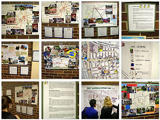
This evening I headed up to the Somerville Central Public Library and checked out the opening exposition of the Somerville Mapping Project, on display through the end of December. It was awesome.
All kinds of individuals, young and old, mapped out on poster board some things that they identified with, liked, disliked, or perhaps just wanted to share with others. There were old photos from the Blizzard of ‘79 and of mom-and-pop stores driven out of business by regional retailers; news articles and notes. These were connected with colorful string or pipe cleaners to their geographical locations on base maps of Somerville.
In addition to these individual projects, everyone collaborated together on one large map, maybe 7 feet square, and mapped out everything from mailboxes, to empty lots and favorite spots in Somerville. There were some really neat cutouts where you could see some locations at different times of the day.
Most exciting of all though was the use of audio recordings. CD players were lent out at the door and you could walk around listening to different people discussing their maps and their community. Little pictures of headphones and number on maps alerted you to set that track on the CD player to listen to an audio accompaniment.
There was a great turnout of community members and some delicious food at the exposition. I was greatly impressed as well with the level of inclusiveness: all of map explanations were translated in English, Spanish and Portuguese. A Spanish translator was in attendance as well and wove in and out of the speeches and recruitment calls made by the organizers at SNC (Somerville Community Corporation) and ESNC (East Somerville Neighbors for Change)
I am glad I went and found a lot of great ideas for the community mapping project I’m organizing in Lowell.
Thanksgiving reloaded
I have been writing blog postings offline on my commute to and from work but just forget to post them when I get home. Sorry for any delays.
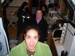
This last Sunday, Jessica and I headed over to one of my coworker’s homes up in Sommerville to nosh on another turkey (squash lasagna for vegetarian Jessica), and all the fixins’ meal. It was delicious.
Danielle, the gracious host, had her dad over cooking the Turkey (20 lbs!) in a galvanized trash can. He’s a big Boy Scout and tells me he has lots of other tricks up his sleave. Judging from the moist and flavorful trash-can-turkey, I would go camping with him any day—or dinner—of the week.
The photo is a little weird; I was so preoccupied with stuffing my face I didn’t think until the end, Hey, why not take a picture?. Everyone was already making their way out the door.
My pigeons in a row

I don’t know anything about Massbank, but the pigeons are lined up like a Coney Island rifle booth. They’d be almost as blue as this sky.
Boston Fallout Shelters
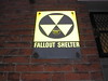 This map lists publicly marked Fallout Shelters in Boston. During the Cold War, Fallout Shelters were built to house citizens in the event of nuclear war. They are usually pretty easy to spot, though sometimes they can be hidden pretty far off a main road. Clicking on marker in the map should bring up a little more information about it (capacity, etc) along with a link to a longer description and some pictures.
Who knows, there is probably a Fallout Shelter right around the corner from you.
Leave me a comment about it below. I’m lazy and can’t go poking into every dirty alley I find. Let me know and I’ll definitely give you credit. If you’ve got pictures and geocoding, let me know.
If you want to go searching, the shelters seem to be in older brick commercial buildings. A lot of buildings have been refaced in recent years and I think that many of the signs have been lost because of it.
If you see a sign, please take only pictures. The Cold War may be over, but I still don’t think you’d want the possibility of a pair of large men in dark suits knocking on your door some cold night.
Call me crazy, but I find the whole mystique—yes, I think there is a mystique—of fallout shelters and civil defense humorously tragic. While today’s geo-political stability is threatened by relatively isolated incidents of aggression, little more than a decade ago the worry was of complete and utter destruction of Earth as we know it.
To protect against this the United States government spent great deals of time, manpower and money. While probably not as much as was spent on missiles, tanks or combat boots, it still represents a substantial effort that went into planning and creating the Civil Defense infrastructure that fallout shelters would be just one part of.
The ludicrousness sets in when you think, Wait a minute, I didn’t know about any of this! In order to avoid scaring everyday people like you and I, The Government! (e.g. your school board and sanitation commission) decided to just not tell anyone about it. Talk about paternalism; it’s like hiding the fire extinguisher because you don’t want people to worry about starting a fire.
Now that it’s all over with, I’m really curious about the whole Fallout Shelter thing. Where the heck are they? What was the total capacity versus population? They are in private buildings. Was the basement rented to the government? Did you get a tax break if you hosted a fallout shelter. Are they still a designated ‘safety area’ or such? Does the city even know where they all are? Why the heck not?
Not to get too off tangent, but I think it’s a little like all those civil war battlefields down in Virginia where you walk around and find rifle casings in the fields. Even though the Cold War was fought elsewhere there are still vestiges of it all around us that we don’t even know about.
No, I’m not crazy or trying to sell you gas masks, radiation pills or authentic WWII German helmets. This is a community mapping project I am doing for fun and as a test bed for a class I’m teaching on community and memory mapping at LTC in Lowell, MA.
Any information contained herein is researched by myself and very poorly. Sources include:
Content Map
This is an example of my googlemap module that I extended from this module by bjornarneson.
It creates map points through parsing local RSS feeds that Drupal produces. Normally these feeds only contain the last 15 posts, but I hacked together a helper module (fullfeed.module) that uses taxonomy.module urls (with cool term parsing) but adds all content in the term (or terms) to the feed.
With each feed I can define a custom marker (.png files I created and uploaded). The markers are all default size and shadow—this is limiting, but it’s a PITA to modify it.
The workflow for this is relatively easy. Pure latitude and longitude data is inputed via location.module—I grab it from maps.google.com because I couldn’t get the geocoding from an address to work, though many of my nodes are from random places and this is much more accurate. I have a vocabulary setup just for mapped nodes (photos, videos, random thoughts, etc), and use these as my feeds. Custom icons I created and FTPed in, though you could just use upload.module and attach them to your map node.
It currently does not support lines, though I am definitely planning on adding them. but I don’t have a good idea of workflow though, considering there is not a standard RSS element and am not sure if it’s going to be too hard to either…
The module now supports lines as a nodeapi hook (like location.module adds lat/long). Each feed can set a custom line color. I don’t know workflow yet whether to keep it like this, or have color on a per-node basis.
There is still the line issue of:
Lastly, there is an issue with posting more than one map on a page (it breaks). This is because every map sets things in the header, and I’m not sure what is the best way to make sure that they only post the important stuff once when there is a list of them.